ARTHUR PEARSON
Charles Arthur Pearson produced a series of Gossipy Guides at the end of the 19th century. Like the Ward and Lock series of guides they were full of photographic material in a handy pocket size. Two guides were produced covering Devon: Guide to Ilfracombe and District (cover title; number 4 in the series); and Guide to South Devon (number 8 in the series). Both volumes were published 1900-1901.
Pearson took maps from different sources to include in his two Devon guides. The map of South Devon included in that guide was a transfer of Bartholomew’s map (see Bartholomew Imperial 8): however, the map of North Devon is taken from the plates prepared by George Ravenstein for George Philip in 1899. The scale reveals that this is a Philip’s map: the scale of 1:200,000 was first used for Philip’s 10-sheet Road Map of England & Wales.
Another local trader also used transfers of this map to produce a folding map: Varnan, Mitchel & Co. Ltd of the Weekly News Office were selling a Tourist And Cycling Map of North Devon District about 1908. The North Devon guide also included a page of small sketch road maps (South Devon had maps for cyclists).
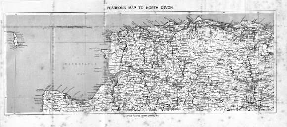
Size: 170 x 450 mm. Scale 1:200 000 or 3.15 Statute Miles to 1 Inch (10 = 80 mm).
PEARSON’S MAP TO NORTH DEVON. (CaOS). Imprint: C ARTHUR PEARSON, LIMITED, LONDON, W C (CeOS) with Copyright (AeOS). Signature: George Philip & Son, London & Liverpool (EeOS). Scale (Aa).
Area covered is from Lundy (Aa) and Hartland Point (Ae) across to Minehead (Ea) and Bampton (Ee). Map is taken from the map produced by Ernest George Ravenstein, Philip's Topographical Map of England & Wales, for George Philip in 1899 (B&B 179).
[1] This volume also includes four very
rough sketch maps (pp. viiia and 1x) of roads in the area.
[2] BL 10358.cc.59 has green cover;
cover title is Pearson’s Gossipy Guide to Ilfracombe and District.The four road
maps are now on pages ix and x. Accession date stamp: 29 OC 1901, the Preface is signed C.H. and it contains
159 pages of which 150-159 are book advertisements plus 8 unnumbered pages of duplicate
ads.


No comments:
Post a Comment